Odyssey of the VOG: Grand Depart
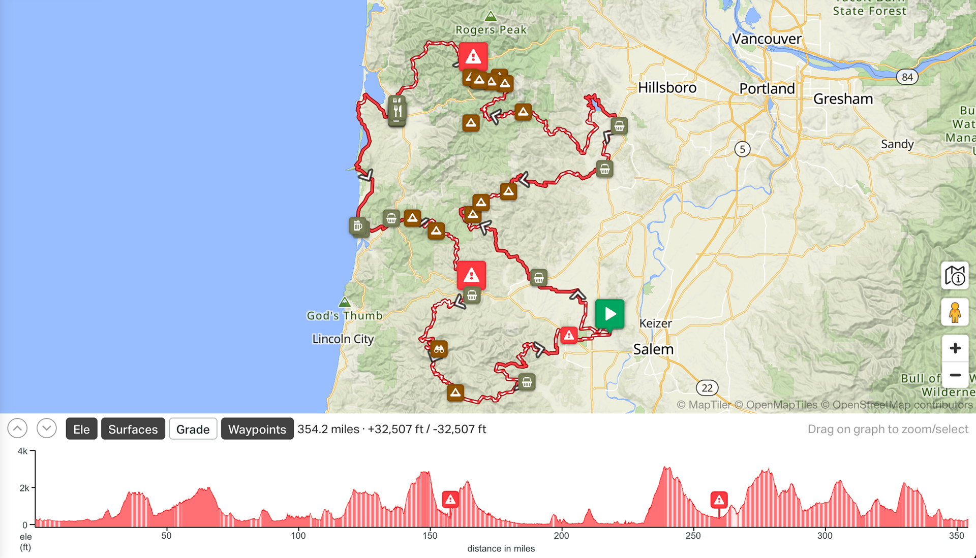
The 2026 counter-clockwise Odyssey of the VOG is the same 354-mile, ~32,500 ft loop ridden in reverse. Same Coast Range gravel, same coastal pavement, same farmland bookends, but the order, the grades, and the resupply math all flip.
Route
Description
The terrain, history, and Valley of the Giants context are unchanged from the standard direction. See the main route description for the full background on the old growth, the Coast Range, and the Triple Crown family of routes. What changes in the reverse is the shape of the ride: a long flat warmup instead of a long flat finish, familiar climbs ridden from the opposite side, and a tired-legs final third through the chunkiest gravel on route.
Route Guide
The route begins and ends at The Grange, just west of Salem. Going counter-clockwise, the first ~20 miles are the old dragstrip in reverse: gravel and pavement rollers through quiet farmland to Sheridan (mile 21), your first resupply.
From Sheridan, the climbing kicks off at Niagara Road around mile 49, the first big Coast Range climb. From there it's a long traverse along the Nestucca River past McGuire Reservoir and down into wine country: Yamhill (mile ~80), with gas stations, convenience stores, and an excellent bakery, followed by Gaston (mile ~90), where small-town hours make resupply unreliable.
From Sheridan, the climbing kicks off at Niagara Road around mile 49, the first big Coast Range climb. From there it's a long traverse along the Nestucca River past McGuire Reservoir and down into wine country: Yamhill (mile ~80), with gas stations, convenience stores, and an excellent bakery, followed by Gaston (mile ~90), where small-town hours make resupply unreliable.
IMPORTANT RESUPPLY NOTE: From Yamhill, you're committing to a 108-mile push to Tillamook with no reliable resupply in between. Yamhill is the must-stop in this direction. Plan accordingly.
After Gaston, the route rolls past Hagg Lake before climbing Trask Road, the second major climb, and descending Alderbrook into Tillamook (mile ~188).
From Tillamook, you head south on 42 miles of coast, much of it on the historic Oregon Coast Bikeway, with a brief gravel stint near Cape Meares around mile 204, through Pacific City (mile ~222) to Hebo (mile ~230).
Hebo is where the route turns inland and the hardest climbing begins. The 8-mile pavement climb out of Hebo feeds into the 2,500+ ft grind past South Point and Mount Hebo before the long descent into Grand Ronde. Hebo Lake and South Lake are good planned-overnight options, with dispersed sites along this section as well.
Drop into Grand Ronde (mile ~259) for resupply, then take on the back half of the classic Falls City to Grand Ronde section in reverse: two 2,000+ ft climbs and a 5-mile stretch of baseball-sized gravel between roughly mile 278 and mile 283. Creeks are plentiful through here, so water isn't a concern, but this is where reversed-direction fatigue shows. The chunky section that fresh legs handle on the standard route hits here at mile 280 with 70+ miles still on the clock.
Falls City (mile ~313) is your last resupply. From there, ride past Aaron Mercer Reservoir with Mount Brown views, climb back over the coastal foothills, and roll the final 15 miles of farmland to The Grange.
If you're at the pointy end of the race, the back half of this version is where it gets won or lost. There is no flat victory lap waiting in this direction.
Resupply Info
(rough mileage estimates)
Sheridan (mile 21), first resupply
Yamhill (mile ~80), MUST-STOP before 108-mile push
Gaston (mile ~90), unreliable hours
Tillamook (mile ~188)
Pacific City (mile ~222)
Hebo (mile ~230)
Grand Ronde (mile ~259)
Falls City (mile ~313), last resupply
Yamhill (mile ~80), MUST-STOP before 108-mile push
Gaston (mile ~90), unreliable hours
Tillamook (mile ~188)
Pacific City (mile ~222)
Hebo (mile ~230)
Grand Ronde (mile ~259)
Falls City (mile ~313), last resupply
Difficulty
Overall Difficulty: 6/10
Overall Difficulty: 6/10. Same metrics as the standard direction, but a meaningfully different shape. The hardest climbing and the chunkiest gravel both land in the back third, on tired legs.
Technical: 6. Same character. The 5-mile primitive gravel section now hits around mile 280 instead of mile 73.
Physical Demand: 8. Arguably harder in this direction. The classic version front-loads the big climbs; the reverse stacks Mount Hebo, two 2,000+ ft climbs, and the chunky gravel into the final 100 miles.
Resupply: 3. Same gaps, just flipped. The 108-mile no-resupply section now runs Yamhill to Tillamook.
Route Development
Ben and Seth are the sole creators of the Odyssey of the VOG Triple Crown of routes. They spent hundreds of hours pouring over maps (#ridewithgps), riding into deadends and rerouting, checking in with timber companies about land use (usually getting denied), and the list goes ever on and on.
Statistics
Miles: ~350
Recommended Number of Days: 4-7
Difficulty: 6
Unpaved: 65%
Paved: 35%
Singletrack: 0%
Rideable: 100% (in theory)