Odyssey of the VOG: Grand Depart
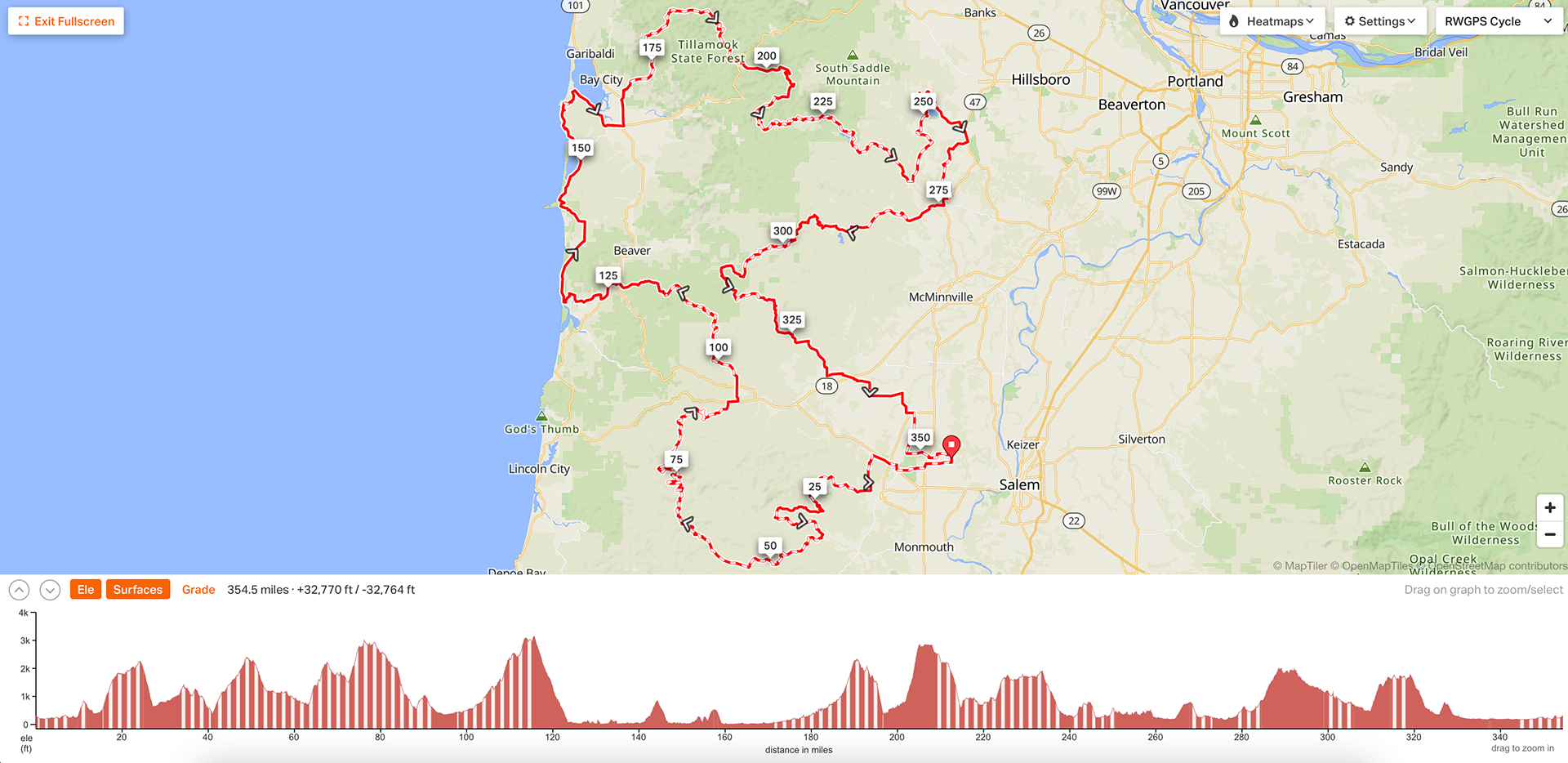
The 2025 Odyssey of the VOG route is a 354 mile route with about 32,770 total feet of elevation gain. The terrain ranges from smooth tarmac to plum-sized boulder-gravel, but most of the route is somewhere in between, a rideable but often vibration-heavy gravel that is synonymous with the timber roads of the Oregon Coast range.
Route
Description
The Odyssey of the VOG (Valley of the Giants) gets its name from the 51 acres of massive old growth forest found on the North Fork Siletz River at the western edge of Polk County, Oregon. Most of these huge trees are Douglas-firs, with a few large western hemlocks as well, many of which are close to 500 years in age.
This epic old growth is a sight to behold, and while most racers will not veer off course at mile 68 of the ride to do the hike itself, the Valley of the Giants is a must-visit destination for anyone touring this route. For the racers, you may not see it, but you’re on the doorstep of a massive old growth forest.
Riding through the coast range is deceptive. Many may expect the Odyssey of the VOG to be easy riding since it is west of Oregon’s infamous Cascade Range. Don’t be fooled. What the coast range lacks in altitude it more than makes up for in elevation grades. On route, expect monster climbs, white-knuckled descents, breathtaking ridgeline views, oceanfront roads, and a start and finish that rolls through quiet farmland. The Odyssey of the VOG is a diverse riding opportunity that showcases the rural Willamette Valley, the rugged coast range, and the expansive Oregon Coast.
The Grand Depart is a big undertaking for many riders - maybe too big for some. That’s why in addition to the Grand Depart route, there are two shorter or mini-VOG routes: the Northern Tier and Southern Tier. The Northern Tier is a great introduction to some of the challenges on the Grand Depart, with waterfalls, a few big climbs, and a great little bikeway lollipop loop that provides a glimpse of the Oregon Coast. The Southern Tier is a more intense and isolated route that showcases the Coast Range-grind style of riding that permeates much of the Grand Depart route, while also offering up two optional hikes - the Valley of the Giants hike and the Niagara Falls hike - that provide amazing views on lesser used trails as well as a welcome reprieve from the saddle.
Both of these optional weekender routes follow much of the Grand Depart but deviate slightly at certain points to provide even more geographical and visual diversity. If interested in any of these three routes, or if you simply want more information, visit the Odyssey of the VOG website: odysseyvog.com
Route Guide
The route begins and ends at The Grange - a small historic site located just west of Salem. The relatively flat start rolls through farmland for the first 15 miles until eventually jumping into the Siuslaw Forest and getting a little taste of the climbing that is to come as you traverse up and over the beginnings of the coastal foothills, with views of Mount Brown as you descend towards Aaron Mercer Reservoir.
Your first possible resupply is at mile 41 in Falls City, where there is a small convenience store, before embarking on a 50 mile push to Grand Ronde, which includes two 2,000+ foot climbs and some of the chunkiest gravel (think baseballs) of the entire route for about a 5 mile stretch. Creeks abound throughout this section, so water shouldn’t be an issue. Just make sure you brought your climbing legs with you.
Grand Ronde at mile 90 has another small convenience store right on route as a second possible resupply option before once again climbing up into the coast range, past Mount Hebo and South Point. This 2,500+ foot climb is no joke, but the gravel quality is decent for such a primitive and rarely traveled area. South Lake and Hebo Lake are both great camping options but can be a bit busy on weekends, so don’t depend on a quiet spot there, if that’s what you’re after. Dispersed camping options can be found along this section, as well, for those using this area as a place to bed down for the night.
After the 8 mile pavement descent to Hebo (another resupply point), you’ll be treated to 42 miles of pavement along the coast, much of which follows the historic Oregon Coast Bikeway - with only a brief stint of gravel riding at mile 150, near Cape Meares.
*IMPORTANT RESUPPLY NOTE: The next two resupply opportunities are Pacific City and Tillamook. Tillamook (mile 160) is a must-stop resupply point for the race, as you won’t have another opportunity to resupply until Yamhill (mile 269), 110 miles away. Since Yamhill is a small town, you may not actually be able to resupply there depending on the time of day, which would mean Sheridan - at mile 328 - is your last resupply opportunity. Plan accordingly.*
From Tillamook, the route briefly continues on highway 101 until veering off on Alderbrook road. The climb that follows starts gradually, but once it begins to climb in earnest, you have officially begun the second set of big mountain climbs on this route.
After the last big climb on Trask road, you eventually descend to the mostly-paved rolling hills Hagg Lake, Gaston, and Yamhill. Gaston (mile 259) can be used as a resupply, but small-town store hours make it a bit unreliable. Your best bet is to ride 10 miles further to Yamhill at mile 269 where there are gas stations and convenience stores - as well as an amazing bakery.
After a resupply in Yamhill, you’ll be climbing and descending along some well-surfaced pavement forest roads past McGuire Reservoir as you follow the Nestucca River - a river that passes by Hebo and Cloverdale before entering Nestucca Bay and the Pacific Ocean. Unless you want to continue towards Hebo and Cloverdale in an endless VOG infinity loop, turn left onto Niagara road at mile 305 (AN EASY TURN TO MISS!) for the last climb through the coast range.
As you descend towards Sheridan (mile 328) and your last resupply point, the climbing is officially over. All that’s left is a dragstrip of gravel and pavement all the way back to the Grange.
If participating in the Grand Depart and at the pointy end of the race, think of these last 20 miles as your victory lap unless you have someone within a mile of you. If that’s the case, the last 20 miles moves fast and an exciting finish is guaranteed.
We hope to have someone to congratulate you at the finish, but if no one is there, pop open that warm beer you had stored in your trunk for the past few days and let the self-congratulatory reflection begin. You just completed a grueling - some might even call it notorious - 350+ mile race and were not a casualty of the Odyssey of the VOG, more than can be said for some of the riders that lined up with you at the start.
Take a moment to sit back and relax; maybe cheer on a couple riders as they roll through the finish over the next few hours; maybe catch up with some of the riders that have already completed. Whatever you do, CONGRATS on what we hope was an unforgettable journey.
Resupply Info
note: rough mileage estimates
Falls City (mile 41)
Grand Ronde (mile 95)
Hebo (mile 123.5)
Pacific City (mile 132)
Tillamook (mile 166) - MUST STOP RESUPPLY
Gaston (mile 264)
Yamhill (mile 274.5)
Sheridan (mile 333)
Difficulty
Overall Difficulty: 6/10
While this route is quite physically demanding with a LOT of elevation gain, it has numerous resupply points, an abundance of water, and some highway bailout options if needed.
Technical Difficulty: 6 - This route has very little washboard and most of the riding is predictable forest road tarmac or gravel. The exception is between miles 71-76, where the ‘gravel’ can be unpredictable and primitive, as well as a few ascents and descents that take 100% focus to navigate. Otherwise, it is pretty classic Oregon Coast Range gravel: rideable gravel roads that are smooth if not a bit vibration-heavy at times. It’s about a 65/35 gravel to pavement ratio.
Physical Demand: 8 - While not technical riding, the Odyssey of the VOG has multiple 2,000+ foot climbs that can really catch up to you after a while. It is definitely a route for people accustomed to hour+ climbs multiple times throughout a day’s ride.
Resupply: 3 - With the exception of the 110 mile push from Tillamook to Yamhill, the resupply options along this route make it pretty easy to worry less about food and water and more about that next 2,000 foot climb on your GPS.
Route Development
Ben and Seth are the sole creators of the Odyssey of the VOG Triple Crown of routes. They spent hundreds of hours pouring over maps (#ridewithgps), riding into deadends and rerouting, checking in with timber companies about land use (usually getting denied), and the list goes ever on and on.
Statistics
Miles: ~350
Recommended Number of Days: 4-7
Difficulty: 6
Unpaved: 65%
Paved: 35%
Singletrack: 0%
Rideable: 100% (in theory)